Indageo
___ Visit the website! ___
Photography is basically an archiving process in terms of the motivation of an ordinary person. To immortalize an event or a view means to store it for the future. There are a lot of services that share these archives with a community wherein we can find the location as an aspect of filtering between the different systematising tools. In short, we can place an image on a map. The concept of our project is based on a different motivation. The aim is to convey the events to others in the community. The importance of real time action is growing instead of the importance of archiving. This fact can both give a special context of the images and can catalyse a conceptual space of the physical environment.
Indageo from Andras Kangyal on Vimeo.
Organising the infrastructure
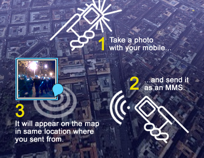
The interaction flow consists of two simple steps. 1. taking a shot with a mobile, 2 sending it as an MMS. For this we had to form a partnership between the two biggest Hungarian MNOs (T-mobile and Pannon) and the most popular Hungarian news portal (index.hu). We think this partnership is very important to reach the critical mass of service’s users. Although MMS is quite an expensive channel, Indageo can provide it for a pretty low price. This MMS service is available in Hungary only. Also, Indageo lets users upload images online, since it will function as the geotagging service for the whole Index community.
Adventures with the GUI
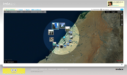
The images are displayed on the Yahoo map as a responsive image carpet. We have designed an unconventional GUI to browse them. One of the hardest design problems of geotagging services is to display too much content on a finite size map. In our case, the problem emerges from the overlapping images. We designed an algorithm which can select the freshest or most rated (alternatively adjustable) images and put them as thumbnails on the map. In contrast the algorithm can also handle single images. The way a lonely image in the middle of the Mongolian desert will be displayed independly on it’s freshness, value rating or zoom level.
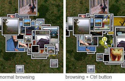
If the user holds down the „Ctrl” key during the browsing then the user can rummage between the overlapping images with the curzor. As the result of the rummage, the surface of the map emerges between the images. The rummage can also illustrate how „thick” the image carpet is.
As another interaction feature, a simple docker can help to browse between the images. If the user’s curzor is above the group of images and the user pushes the “space” button, the images from the curzor’s neighborhood will be re-arranged around a ring. Following this, the user can point to the images and a small blue sign shows the original position of the pictures.